Haute-Savoie au Sommet: pass reserved for cyclists
Tuesday 12 August 2025
09:00 to 12:00
Location : Col de Joux Verte


Presentation
This summer, get on your bike and climb a legendary mountain pass in complete freedom, on roads reserved for cyclists.
Take advantage of an emblematic pass every Tuesday and one Sunday from 9am to 12pm to enjoy a unique cycling experience, without motorised vehicles.
Take advantage of an emblematic pass every Tuesday and one Sunday from 9am to 12pm to enjoy a unique cycling experience, without motorised vehicles.
Thanks to the Conseil départemental de la Haoute-Savoie: the passes are yours!
Whether you're a seasoned cyclist or simply a fan of two wheels, treat yourself to a moment of pleasure, in complete safety, away from the traffic, to fully appreciate the scenery and challenges of Haute-Savoie's finest climbs.
- free of charge ;
- no registration ;
- no time limit, no competition;
- Just you, your bike and the road!
Nota bene: no refreshments provided.
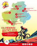
Dates:
- Tuesday 01 July: Col de Solaison via the RD186 and RD186A (12 km including 8.7 km closed to traffic) from Le Thuet
- Tuesday 08 July: Col de Leschaux via the RD912 (12.8km including 9.3km closed to traffic) from Sévrier
- Tuesday 15 July: Montée d'Ajon via the RD 190B (9 km including 6 km closed to traffic) from Onnion
- Sunday 20 July 2025: Col de joux Plane (both sides from Samoëns and Morzine) via the RD 354 (20km)
- Tuesday 22 July: Col des Pitons (Salève) via the RD 41A (10.6km including 7.5km closed to traffic) from Cruseilles
- Tuesday 29 July: Montée de la Sambuy via the RD 112 (6.3km including 5km closed to traffic) from Seythenex
- Tuesday 05 August: Ascent of Semnoz via the RD 41 and RD 241 (17 km including 11 km closed to traffic) from Annecy and Quintal
- Tuesday 12 August: Col de Joux Verte via the RD 228 (13.5 km including 10.5 km closed to traffic) from Lac de Montriond.
- Tuesday 19 August: Col de Cou via the RD 12 (8.5 km closed to traffic) from Annecy and Quintal.
Whether you're a seasoned cyclist or simply a fan of two wheels, treat yourself to a moment of pleasure, in complete safety, away from the traffic, to fully appreciate the scenery and challenges of Haute-Savoie's finest climbs.
- free of charge ;
- no registration ;
- no time limit, no competition;
- Just you, your bike and the road!
Nota bene: no refreshments provided.
Dates:
- Tuesday 01 July: Col de Solaison via the RD186 and RD186A (12 km including 8.7 km closed to traffic) from Le Thuet
- Tuesday 08 July: Col de Leschaux via the RD912 (12.8km including 9.3km closed to traffic) from Sévrier
- Tuesday 15 July: Montée d'Ajon via the RD 190B (9 km including 6 km closed to traffic) from Onnion
- Sunday 20 July 2025: Col de joux Plane (both sides from Samoëns and Morzine) via the RD 354 (20km)
- Tuesday 22 July: Col des Pitons (Salève) via the RD 41A (10.6km including 7.5km closed to traffic) from Cruseilles
- Tuesday 29 July: Montée de la Sambuy via the RD 112 (6.3km including 5km closed to traffic) from Seythenex
- Tuesday 05 August: Ascent of Semnoz via the RD 41 and RD 241 (17 km including 11 km closed to traffic) from Annecy and Quintal
- Tuesday 12 August: Col de Joux Verte via the RD 228 (13.5 km including 10.5 km closed to traffic) from Lac de Montriond.
- Tuesday 19 August: Col de Cou via the RD 12 (8.5 km closed to traffic) from Annecy and Quintal.
Event Organizer
Département de la Haute-Savoie
Phone : +33 4 50 33 50 00
Location
Col de Joux Verte
RD228 route des Lindarets
74110
Montriond
Tarifs
| Fares | Min | Max |
|---|---|---|
| Free | ||
Destination
RD228 route des Lindarets
74110
Montriond
GPS coordinates
Latitude : 46.206987
Longitude : 6.768059
Col de Joux Verte via the RD 228 (13.5 km, 10.5 of which are closed to traffic) from Lac de Montriond.