Montriond Lake route


Presentation
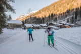
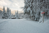
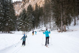
A site deep in a valley where there’s an imposing cliff-face and fir trees all around.In winter, the lake is frozen, in places a metre thick.The magnificent Nordic area is perfect for cross-country skiing.
No ski pass necessary.
Offers 4 cross country ski routes:
• Along the lake on the left of the river looking down the valley (green level)
• From the end of the lake to Les Albertans hamlet (red level)
• 2 ski slopes from Les Albertans to Ardent (green and blue level)
The slope along the lake may be out-of bounds if the avalanche risk is high.
Carte : IGN TOP 25, 3528 ET, Morzine
Closed temporarily.
Destination
Itinéraire du Lac de Montriond
74110
Montriond
GPS coordinates
Latitude : 46.210279
Longitude : 6.725006
Access by road: A40 (exit 15 Vallée verte), D903 until Fillinges, D907 until Taninges, D902 until Montriond
Train station: Thonon (30km) or Cluses (30km)
Airport: Genève (64km)
Train station: Thonon (30km) or Cluses (30km)
Airport: Genève (64km)
Tarifs
| Fares | Min | Max |
|---|---|---|
| Free | ||
Free of charge.
We also suggest...
- Montriond