Hike to Pointe de la Croix
- Level orange - quite hard

 Departure/Arrival
 Point of interest
Presentation
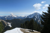
Superb hike to the Pointe de la Croix. On the program: superb views of Roc d'Enfer, Mont Blanc, Dents du Midi, Cornettes de Bise, Mont de Grange, Dent d'Oche, Pic de la Corne...
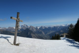
It's a summit that has to be earned. The climb from La Chaux is steep. The route takes you on a loop that crosses 3 key axes: la Chaux, la Pointe de la Croix and the Col de l'Ecuelle. The views are well worth the trip to the top. From the Pointe de Cercle (Pointe de la Croix's little sister), you'll overlook the Abondance valley, with views stretching as far as Lake Geneva to the north and the Dents du Midi to the east. The route is not particularly technically demanding, nor is it dangerous, but you'll need good legs. You will reach a ridge from the Pointe de Cercle, though the path is well away from the cliff, so it's best to avoid getting too close.
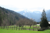
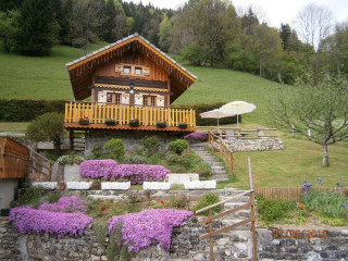
If you like to take your time, consider the route over the course of the day: set off in the late morning to arrive at lunchtime at La Chaux (one hour from the start). Enjoy your picnic in the sunshine with a superb view over the Vallée d'Aulps, with Mont Blanc and the Roc d'Enfer in the background. Take your time and head off in the direction of Pointe de la Croix. Here, you'll enjoy some of the best views of the entire route. After a well-deserved break (a little more shade this time), head back down to the Col de l'Ecuelle and then to the parking lot. Along the way, you'll see some charming chalets, full of authenticity.
If you like to take your time, consider the route over the course of the day: set off in the late morning to arrive at lunchtime at La Chaux (one hour from the start). Enjoy your picnic in the sunshine with a superb view over the Vallée d'Aulps, with Mont Blanc and the Roc d'Enfer in the background. Take your time and head off in the direction of Pointe de la Croix. Here, you'll enjoy some of the best views of the entire route. After a well-deserved break (a little more shade this time), head back down to the Col de l'Ecuelle and then to the parking lot. Along the way, you'll see some charming chalets, full of authenticity.
- Informations Itinéraire :
- 9 km
- 792 m de dénivelé
- 245 minutes